A few weeks ago I found myself in the position of having three days off of work perfectly coinciding with the three warmest and sunniest consecutive days western Washington has had all year. Without a doubt, I was planning a hiking trip. I spent a lot of time on the WTA website, searching for a hike between 25 and 50 miles long that wouldn’t have more than a few miles of snow but would still reach a nice alpine setting, ideally a lake. In mid-June, this didn’t turn up a ton of options, but one stood out–LaCrosse Basin by the North Fork Skokomish River Trail.
The trail hugs the North Fork Skokomish River for the first 10 miles. This section is well-used with a handful of camping spots on the trail and forks to other popular destinations. It starts at 800 feet and climbs gradually for a while–800 feet over 9.6 miles. Over the next 3 miles, it leaves the river and climbs more steeply to it’s highest point, First Divide (4,688 ft) before dropping 2200 feet over the next two miles and joining the Duckabush River Trail. It is almost 4 miles from there to Marmot Lake (4,4000 ft), the lowest elevation lake in the LaCrosse Basin. I knew that I would almost certainly encounter snow at First Divide and Marmot Lake, but I had reasonable hope that it would be passable.
6/17: To Upper Duckabush Camp, ~15 miles
I woke before my alarm, so ready get going. Sunday early morning traffic was a breeze. With the Staircase Ranger’s station less than three hours away from Seattle, I made it there before they even opened. I waited until I could talk to someone about the trail, but I didn’t learn much. He said there were no recent trip reports but there would definitely be snow around First Divide, both of which I already knew. I decided to go for it but made a contingency plan. If the snow was too much, I would turn back and take a side trail to a closer lake.
With my plan and permits, I set out at 9:50. Immediately summer was apparent. Anywhere that leaves could be, they were–filling out tree branches and sprouting from the ground, hanging in the air and floating with the breeze, shimmering with sunlight below me and glowing green above. The air, cool under the trees’ canopy, was warm and slightly humid in the sunny clearings. There, the scents of ferns, bushes, and wildflowers, earthy, sweet, and sharp, combined into something I can only describe as green and living. Buzzing fuzzy bees and fluttering butterflies circled flower clumps while dragonflies zoomed by above. Birds chirped and darted between branches. All this below a perfect blue sky dotted with wispy cloud puffs and over the constant sound of the rushing river and rustling treetop leaves.
It felt like place from a memory, with a dreamy luster usually only added by time. I soaked it all in, striding forward on the trail but floating in the moment, completely forgetting the work and preparations of the past few days and the snow-covered trail ahead. So were the first nine miles. I saw 4 or 5 other parties, headed back to the trailhead.
I had tentatively planned to stay at Two Bear camp (mile 11.6) that night, but it was only one thirty as I was approaching Nine Stream (mile 9.2), the last place to hang out by the river before the climb to Two Bear. I had so much time, it was a beautiful day, I felt I should maybe take a break. But with all the pocket snacks I had, I didn’t need to stop for lunch. Based on how much I didn’t want to stop, I realized I was pretty eager to get higher up and decide if the trail was passable. I got to Nine Stream and continued onward.
The trail got steeper after Nine Stream. So far this year I had done some days of hiking with a full pack, and I had done some hiking with a lot of elevation gain. But I had not yet done hiking with a full pack and a lot of elevation gain, and I really felt that here. Right away my heart rate spiked and my legs, which had felt great so far, started to feel expended, like they lacked energy. And strength. And endurance. Thankfully the trail soon let up a bit, changing from moderately steep to a solid, manageable uphill. The terrain slowly changed as well and I was rewarded with some awesome alpine views.
Around 3, I reached Two Bear, and the first snow. The trail was solidly covered for a few 10 to 20 foot stretches. I paused to consider my plan. It would be 3 miles before the trail reached this elevation again. At worst, three miles of snowy and difficult terrain. At worst, I might travel one mile per hour, and at worst, I might go two miles and turn back. But with six hours until dark, I had time for any scenario.
And it turned out, that was the most significant snow for almost the next mile. After a mile, snowy stretches became longer and I started to need my map to help me pick up the trail. There could have been other hikers there in the last few days, but in that heat, with the sun beaming down, there was no hint of human footprints in the snow. I did, however, see some very recent bear tracks.
Around a quarter mile from the top I was surprised to encounter two others headed the opposite way with no overnight packs. In few words, as they seemed in a big rush, I learned they started that morning at the Duckabush River trailhead, over 20 miles away, and were headed to Staircase, where I had started–you know, doing a little through run. Just seeing them was reassuring, with their trail runners and trekking poles, and knowing that they had come over First Divide. They did say there was a lot of snow, but I had figured that already. I just new now it was possible without serious gear, and I had tracks to follow!
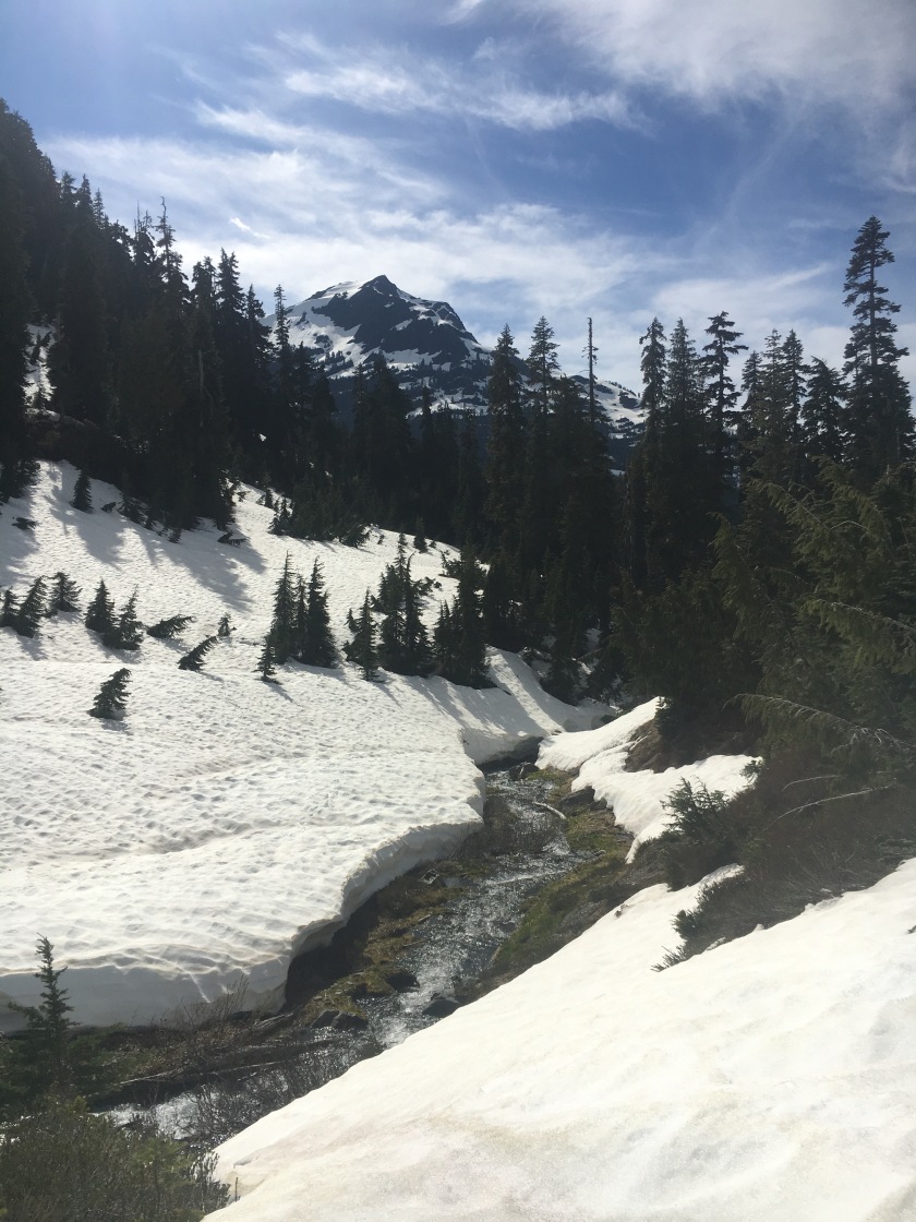
As pretty much everything was covered in snow from there on, the tracks really really helped. Keeping my map handy to confirm that the way made sense, I followed those trail runner tracks, trudging up, over, and across the rolling clearings. At some point I saw a little tarn ahead, a round depression in the snow, with glacial blue melt collecting in a semi-circle. Aha! I remembered from the map that First Divide is right where the trail passes a tiny pond. And looking around, I realized that I was on something of a saddle. I made it to the top!
I wanted to take a short break, but I needed to find some cover from the blinding white. Standing on a snowfield at a higher elevation in the middle of a cloudless June day, the sun is about as strong as it will ever be in Washington. I settled in the shade of a cluster of trees on a little knob, thankfully on dry ground. I ate a chocolate pro bar and began to appreciate where I was. Since traipsing through the flower patches that morning, my state of mind had slowly shifted from entirely carefree to completely focused on movement and navigation. I had to make myself pause to take it in.
The landscape had a charm very different from the lush utopia of the river valley. It was completely pristine–perfect in some ways, something messy underneath simplified into snow, tree, and rock. Without ferns to sway and leaves to flutter and bugs to buzz, it felt quiet and static. Like a movie set. I kept thinking of the claymation Rudolph. These things, combined with the fact that it is objectively less hospitable to humans, contributed to the feeling that I didn’t belong, I was just visiting. Probably an appropriate feeling to have as a modern human in an alpine setting. Of course, it was awesome to be visiting there.
After a short while, it was time to keep moving. I reapplied sunscreen, studied the map, and headed back onto the bright stage to get a look at the way forward. To the north, I saw the basin I would soon cross, covered in snow and split by two creeks, but from my vantage point I couldn’t tell much about the slope, dropping 400 ft, between me and there. Oftentimes the best path to take on a slope seems different looking down than looking up. And looking down, I really did not want to follow the trail runners’ tracks, which headed straight down the gradually steepening slope and then dropped out of my sight, down an even steeper slope. They had had the better vantage point when they chose that way, so I figured it had some advantage. But I wanted to at least try to find something else.
It was impossible to be sure about a good path from the top–any clump of trees could be hiding a steep drop off. But with the trail somewhere below the snow, I knew there was at least one reasonable path. I chose a direction with a safe fall line and made my way down diagonally, turning when I got a better vantage point of terrain below. The snow was a perfect consistency for this. I could stomp solid steps with my trail runners and use my shortened trekking pole like an ice axe. If I fell, I would have definitely been able to self arrest in that soft snow, but I made sure to keep my fall line pretty safe anyway. I got to a point where I did see a short bit of trail, serving as a stream bed for snowmelt. I followed this until it was obstructed by a giant blowdown. After scrambling up and around the fallen tree, I could see a clear path down the snow!
It wouldn’t have taken too long to plunge step down, but it was roughly 200 feet without any obstacles–a perfect glissading opportunity. I stopped to make sure everything was secure on my pack, edged my way to the best starting point, and slid down on my butt with my trekking pole as a rudder. By the time I petered to a stop, I was nearly on flat ground. Phew! From there, it was not too difficult to make my way across the basin. My shoes were so wet from snow that I made no attempt to find dry crossings of the small creeks. As I headed in the rough direction of the trail, I picked up the trail runner tracks again, almost melted away by now. I found the trail, and before too long, it was snow-free again (:
A mile before camp, just after I passed the 3500 ft, Stoves Only sign, I heard loud rustling ahead. When I rounded the bend I saw a black bear lumbering away! I paused to give it lots of time, and then continued slowly on the trail, making plenty of noise. But that was all I saw of the skittish little guy. I never hiked particularly quietly before, but after that I made a point to make some noise as I walked.
The rest of the way was uneventful, and at 5:45 I reached the junction with the Duckabush River trail and very shortly afterward, Upper Duckabush camp. I set out to find my spot for the night. I explored pretty thoroughly but I was not jazzed with the options. Removed from the river and nestled in forest, it was a pretty large place, with at least six different areas that had their own fire pit and logs to sit on and would accommodate a few tents. I imagined it on a weekend later in the summer–lively, with families and groups of friends hanging around campfires, talking into the night. But that night, all of those spaces were empty, the privy door crooked, a frying pan hanging on the bear wire, and a pair of old socks on the line. Alone in a space made for so many, I felt like I was creeping through an abandoned building, or a vacation home in the off season.
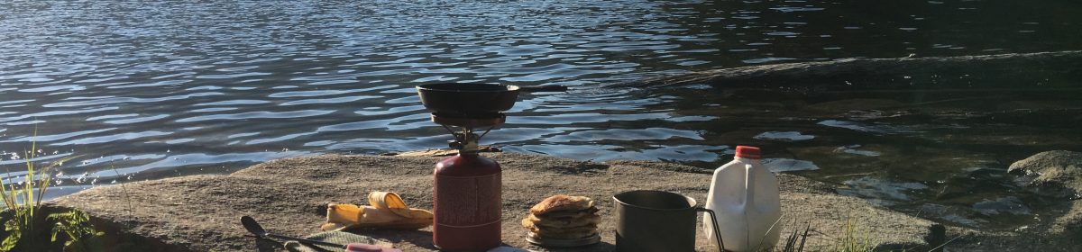
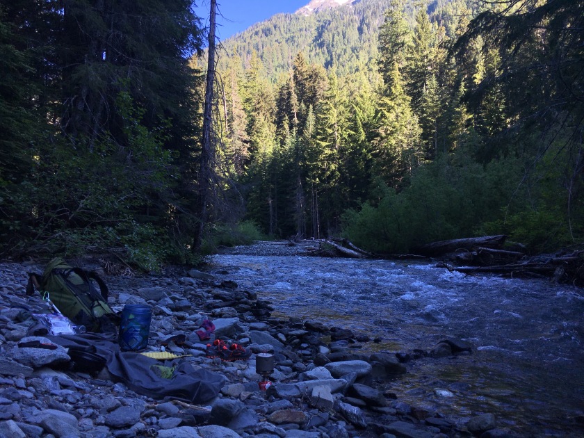
I realized this was the only option for sleeping, but I could wash and eat dinner somewhere more cheerful. I went back to the junction, where, in the other direction, the trail crosses a large creek. I set up at the creekside, washing, changing, gathering water, and cooking dinner. It was a lovely spot. I had Rice-a-roni white bean soup, a combo of two great instant meal selections from my local QFC. I cleaned up, brushed my teeth, and got pretty much ready for bed. I stashed my bear can, and back at camp I had just to unroll my bivvy and blow up my sleeping pad before I was ready for sleep. So close to the solstice, daylight lasted a while. I fell asleep before dark, with my hood pulled over my eyes.


6/18: To Marmot Lake, 3.7 miles
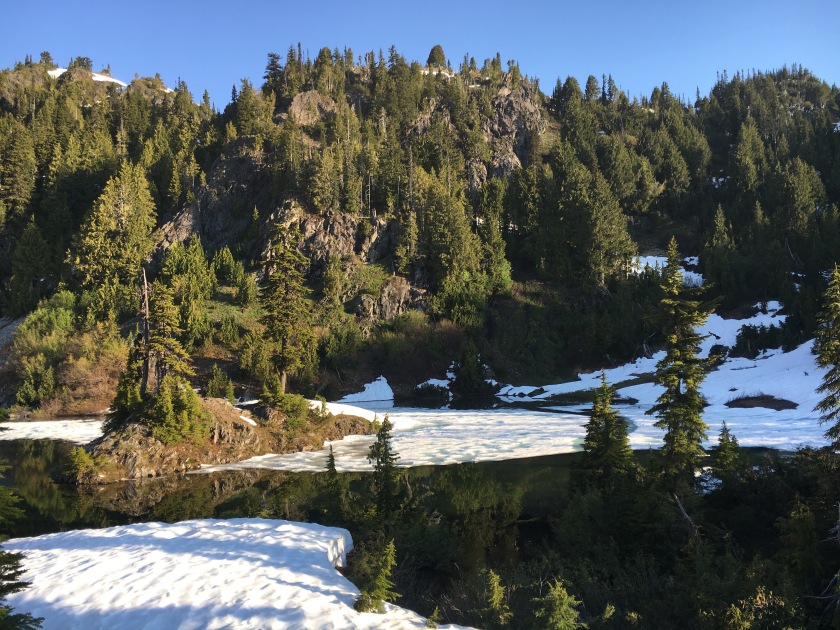
The next day, I planned to make it to Marmot Lake, 3.7 miles away, and stay there overnight. Based on conditions around First Divide, which reached 4688 ft, it seemed very likely that the lake, at 4,400 ft, would be at least partially surrounded by snow. The big unknown was whether there would be any dry spot to camp near the lake. If not, I would have to work something else out. I had other plans in mind, but none were really ideal. It would be really nice if I could stay at Marmot Lake.
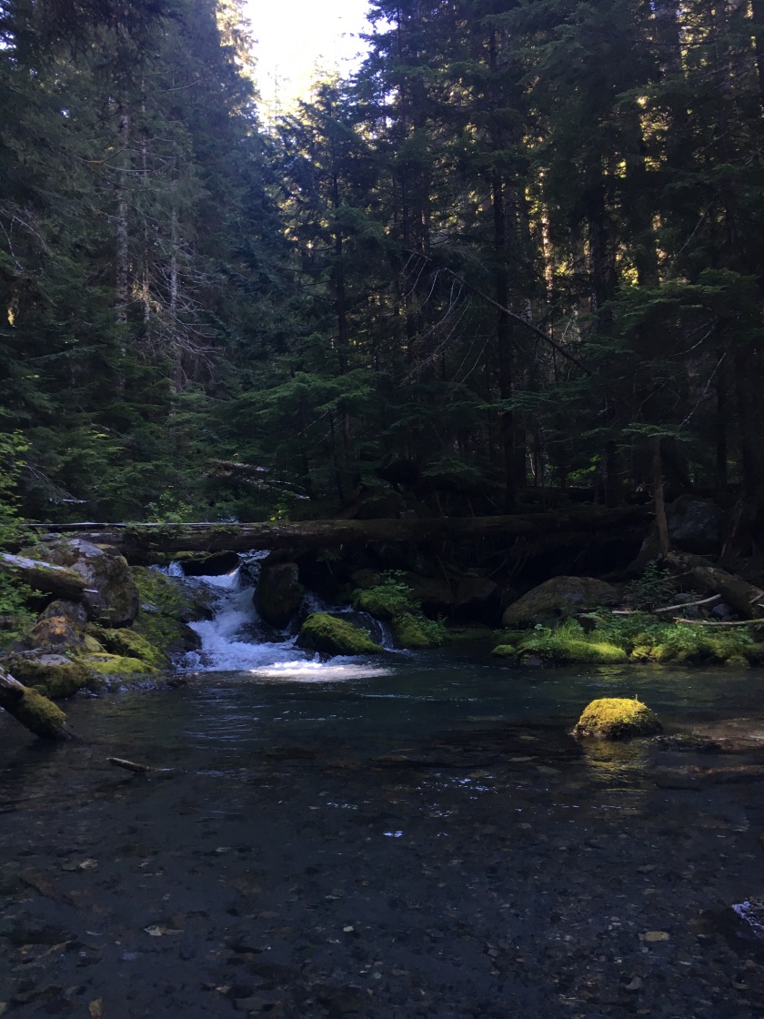
With this background uncertainty about the day, I was not entirely relaxed as I went about my morning routine. It was just light when I woke, well before the sun’s rays would reach the bottom of the narrow river valley. I stayed in my bivy for a while, catching up my journal with the details I was too tired to coherently put down the night before. When the chill in the air had dissipated a little, I emerged from my cocoon, collected my things, and moved to a spot along the Duckabush River to eat breakfast and get ready for the day. As the way started with a creek crossing, small but definitely requiring me to have wet shoes, I waited for direct sun to get going.
That first creek crossing was easy, not quite reaching my knee. The water looked about three inches lower than the night before, but as it was not particularly swift, it would have been fine to cross in the evening as well. I was wearing just my hiking shirt and underwear, having waited to put my pants on until I got to the other side. But once I got to the other side, I thought of how I had another crossing to do in less than three miles. And the chances of encountering anyone else were very low. I decided to leave things how they were.
As I scrambled over trees and pushed my way through ferns and bushes over the next 2.4 miles, I questioned this decision many times. But I never stopped to change. This segment of trail had a lot of the same beauty that the first nine miles had, as well as some stunning waterfalls and sweeping views of the surrounding ridges. The first snow was really surprisingly early, at just 3300 ft. A very narrow and steep gully holding a pleasantly cascading creek was filled up with deep and solid snow, melted through in places in the middle. A few days before, I imagined it would have been a very safe snow bridge. In a couple days, it would probably be easy to access and cross the creek through gaps in the snow. But on that day, it took a little bit of time to figure out how to safely get down to the creek and back up to the trail over the thick snowbanks.
I didn’t see snow again really until the next water crossing, soon before the trail began climbing to the lake. This creek was higher volume than the one before. In the 30 yards closest to where the trail crossed, one spot looked manageable. I sidestepped across, facing upstream and leaning forward on my trekking pole. It definitely required more careful foot placement than the one before, and the water went up over my knee, but I felt stable the whole way. A little bit higher, and that one might not have felt so comfortable.
This time, I did stop to put pants on. I would be getting to snow soon and I needed them for sun protection if nothing else. The rest of the way to the lake was surprisingly alright. No snow on the trail above 3700 ft, the final bit was steep but good terrain. Right as the trail started to flatten out and approach the lake, everything was snow-covered. I found a tiny bit of lakeshore that was snow-free and shaded if I crouched under some brush. I laid down a groundsheet, took off my shoes, took out some snacks, and began to relax a little. Man. It was so beautiful. But it didn’t look like a place to spend a day and night. Initial excitement and relief about getting there slipped away as my gears started turning.
It was half past eleven. It took about two hours to get there. If I only went back to Upper Duckabush, I could hang out at the lake most of the day. But I didn’t really want to camp at Upper Duckabush again. And I worried that the nearest water crossing would be too high if I waited to turn back. To go further, to Two Bear, I would want four more hours, to be generous for the climb to First Divide and all that snow. But Two Bear wasn’t a particularly pleasant campsite–the flat tent sites had pooling snowmelt when I went by the day before–so I would really like to get to Nine Stream: one more hour. I didn’t like it, but it looked like I had seven more hours of hiking ahead of me.
I’d have to get going soon, but after coming so far, I wanted to enjoy the destination a little. I made an attempt at swimming, but the water was very shallow near my patch of shore, and after getting wading out knee-deep, there was no way I was going further. It felt as cold as the snow that sat atop it a few yards away. I ate a bit more–salmon jerky, dried apricots, and a chocolate pro bar–and checked the time. Noon. It felt a little anti-climactic, but I needed to get moving. I packed up and after re-joining my footsteps in the snow, I decided to scramble up the the snowy knob southwest of the lake to check out the view of the valley I just travel through and the peaks on the other side.
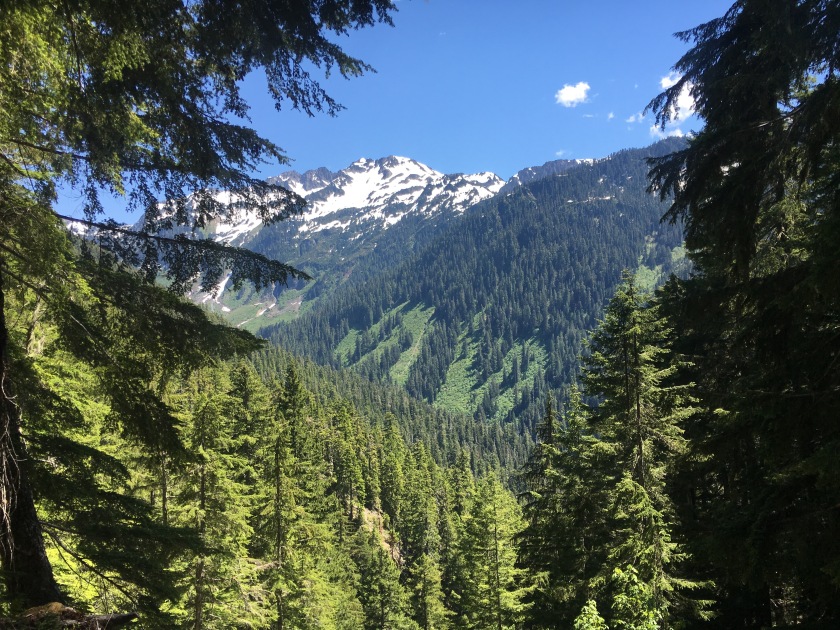
I got up there to find an unobstructed viewpoint of Mt Duckabush, Mt Steele, and the Duckabush River valley. OK. I decided I could delay just a little longer to take in the incredible sights. I took a timed photo with myself in it and scrambled around the dry patches of dirt and rock along that rim of the lake basin. What a shame, I thought. This would be such a great place to hang out. Some of the spots were even flat enough I could spread my ground sheet and read or nap. Wait a minute. Flat, dry patches I could spread out and sleep on… I couldn’t believe it took me that long to realize these were actually tent sites.
So, with many, many hours of day left, I reversed my plan. I would stay by the lake all day. I found a spot with a great view in the shade of a few small trees and made a nest. I worked on a Ken Ken, sketched Mt Steele, listened to an audiobook, and did some stretches. The sun quickly dried my wet shoes and socks. Periodically a hummingbird would zoom above. At 3:30 I heard a helicopter. I emerged from my spot and watched it fly past, headed southwest rather quickly. As it disappeared and the sound faded, I felt aware of being very remote. I wondered how far away the nearest human was–three miles, five miles, maybe even ten miles. The isolation was both lonely and liberating, leaning towards liberating. For that day, this most amazing place was all mine.
Having had so much time to enjoy the spot, and with a big day of hiking ahead of me, I went to bed quite early, set up in a spot which would get the sun’s first rays.


6/19: Back to the trailhead, ~19 miles
The sun did hit me very early, so even after hanging out in my bivvy a short while and letting the condensation dry off my sleeping bag, I was back on the trail at 7. I could see the difference that one day made in the snow and water conditions. Even hitting it so early, the first water crossing was a little higher than the day before, though still very doable, and my suspicion that it would have been too high in the evening was reinforced. And as I expected, getting over the snowbanks to cross the stream in the snowy gully was already so much easier than the day before.
Back at Upper Duckabush around 9, I starting to feel good about making it out that day. Though my original plan had been to spend another night on trail, a shower was very alluring right then. I just had to climb 1700 feet of trail and then about 500 feet of snow and I would be sure I had enough time.
And it turned out to be very alright, getting over First Divide. It was easier to navigate the slope from the bottom, and traveling up the snow required enough focus that I wasn’t so aware of how strenuous it was. And before 11, I was at the top, ready to cruise the 12 or so miles down to the trailhead.
The trail had the same beautiful weather and all the same beautiful, sights, plants, streams, and butterflies, but once I had a real meal, a shower, and my bed in mind, I kept a steady pace. I did stop at Camp Pleasant, 6 or 7 miles from the trailhead to eat and dry my shoes, but I kept it short, set on getting to my car before 6. And I did, happy to have had such a great trip, and happy to be going home.


